
The maps show the change of Pentland from 1980 to 2007. Summarize the information by selecting and reporting the main features, and make comparisons where relevant.

Sample Answer The maps show the change of Pentland from 1980 to 2007.
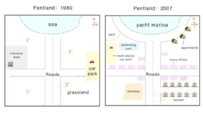
The given maps illustrate the information regarding the changes in Pentland between 1980 to 2007.
In the case of the year 1980, the sea was located on the Northside as well as roads were constructed in the heart of the Pentland. Further, on the left side of the road was an industrial area and the opposite was a car park. Furthermore, grassland was on the southeast corner this year.
However, in the year 2007, there were many changes, such as she was replaced with the yacht Marina. Grassland was used for houses, and roads were in the same place. Moreover, in the left corner cinema was newly introduced. The multi-storey car park took the place of industrial area in the west side as well as park, and the swimming pool was built in 2007 in the Pentland. Last but not least, the area of the car park was used for apartments and various shops.
Overall, after twenty-seven years in the Pentland, the cinema was built for entertainment purposes, and many other new areas were constructed like a park and swimming pool.
Follow Us on IELTSDATA Twitter
Also, Read The chart below the global sales of different kinds of digital games.